Tropical Storm Cristobal Causes Severe Weather From Gulf Coast to Michigan

UNITED STATES—June 10, 2020—Tropical Storm Cristobal, which formed in the Gulf of Mexico on June 2, made landfall Sunday in southeastern Louisiana with sustained winds near 50 mph, bringing 3.5 feet of storm surge to New Orleans and up to 6.2 feet at Shell Beach, La. to the east, according to The Weather Channel. The storm spun off heavy rainfall to the east, drenching much of Florida. The rain caused flash flooding in Jacksonville, Fla., and Suwannee Springs, Fla. received more than 13 inches of rain. Tropical Storm Cristobal’s outer bands also caused several tornados, including one that tore through Orlando.
After drenching the Gulf Coast, Cristobal tracked inland through the Midwest, remaining a tropical depression all the way to Dubuque, Iowa. Its remnants continued across Wisconsin and Michigan, making Cristobal only the fourth tropical system on record to reach Wisconsin, according to The Weather Channel. The storm system raked heavy rain, high winds, and damaging thunderstorms across the Midwest, causing flash flooding from Arkansas and Mississippi to Wisconsin. The path of the storm saw reports of flooded roads, mudslides, downed trees, and power outages.
Tropical Storm Cristobal Threatens Gulf Coast
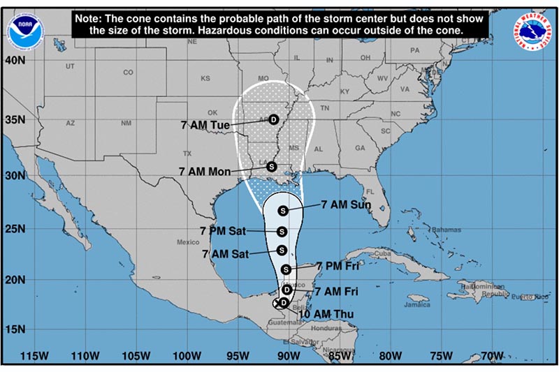
UNITED STATES—June 4, 2020—Tropical Storm Cristobal formed in the Gulf of Mexico on Tuesday as the third named storm of the Atlantic hurricane season, which just officially began on Monday. This is the first time on record there has been three named storms so early in the season. Wednesday morning, the storm made landfall west of Ciudad del Carmen, Mexico, where it has dumped as much as two feet of rain, causing life-threatening flash floods and mudslides, according to CBS News. The storm is expected to linger over Mexico through Friday morning as a tropical depression before it moves back into the Gulf of Mexico. Forecasters predict the storm will strengthen back to a tropical storm as it tracks north, with landfall possible anywhere from eastern Texas to Mississippi on Sunday, according to The Weather Channel.
The Weather Channel forecasts that Tropical Storm Cristobal will have a large wind field and heavy rain bands spreading far to the east of the storm’s center. This is expected to bring heavy rain and flooding from Louisiana to the Florida Panhandle and possibly the Florida Peninsula. Rainfall Sunday through Monday is expected to be 4-6 inches with some isolated totals possibly over 10 inches, according to CBS.
The large wind field will cause high surf throughout the Gulf Coast with the highest storm surge expected midday on Sunday from Louisiana to the west coast of Florida. CBS reports some wind damage is also expected, including downed trees and power lines with possible power outages. In preparing for the unique challenges of this year’s hurricane season coinciding with the COVID-19 pandemic, Florida Power and Light has warned that power outages may take longer to restore following this season’s storms. Officials are encouraging residents to make their preparations early and with the pandemic in mind—including adding masks, sanitizer, and cleaning supplies to their hurricane kits and securing enough supplies to handle extended power outages.


